Current Monitor™
Ocean Surface Monitor
sigma S6 Current Monitor™ is a radar-based monitoring system that delivers ocean surface current data from moving stations and both current and bathymetry from fixed locations with high spatial resolution. This greatly improves the management of marine-based activities such as predicting oil slick drift patterns, enhancing navigational safety, and protecting vulnerable coastlines.
BROCHURE

Real-time Current Data at your Fingertips
View the surface current measurements surrounding your operation at a glance, allowing you to make safe, and more informed decisions.
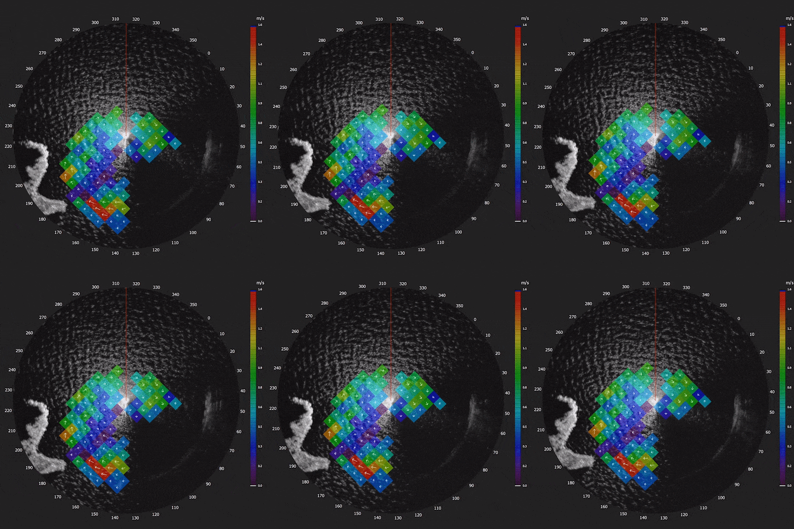
Each coloured box represents an area of down to 50m x 50m or as determined by the operator. The colour of the box indicates the speed of the current, while the arrow indicates the direction of the current.
sigma S6 Current Monitor™ Overview
BENEFITS
Improve Planning and Decision-Making
Having the ability to see surface currents in real-time and gather bathymetric data up to a 30m depth improves decision-making and planning for coastal marine and terrestrial assets. Dredging operations, new construction and oceanic science benefits from visually identifying and accurately measuring surface currents within X-band radar coverage.
Reduce Risk Navigating
Reduce the risk associated with harbour entry and navigating treacherous and challenging waterways. Current Monitor™ gives navigators valuable insight to improve decision-making.
Aid Oil Spill Clean-Up
Pair with sigma S6 Oil Spill Detection to track oil on water during clean-ups, using valuable surface current information to help determine optimal deployment of equipment.
Cost-Effective
Avoid high operational costs associated with in-water sensors. With minimal maintenance costs, better manage long term expenditures.
HIGHLIGHTS
- Day or night, in varied conditions, sigma S6 Current Monitor™ gives mariners assurance in situations where precision and accountability are paramount. The more you know about your immediate environment, the better.
- As a ‘bolt-on’ to most industry-standard marine radars, Current Monitor™ gives the user visibility into real-time ocean surface current and bathymetric information to optimize decision-making time.
- Either as an alternative to in-water systems or as a complement to buoys, Current Monitor™ requires no costly servicing.
- Visualize surface current measurements surrounding your operation at a glance, allowing you to make safe, and more informed decisions.
FEATURES
High Resolution Current Measurement
sigma S6 Current Monitor provides high spatial resolution current maps in 50m-200m grids providing surface current speed and direction. Current measurement is available for vessels underway, stationary platforms, or coastal installation.
Shallow Water Bathymetry
On stationary platforms or coastal sites, sigma S6 Current Monitor provides bathymetry maps in shallow water up to 30m in depth.
Remote Viewing and Control
System allows ability to view and control the system remotely from multiple locations with options to operate under low bandwidth conditions when necessary.
Around the Clock Coverage
High Resolution Current Measurement
sigma S6 Current Monitor provides high spatial resolution current maps in 50m-200m grids providing surface current speed and direction. Current measurement is available for vessels underway, stationary platforms, or coastal installation.
Shallow Water Bathymetry
On stationary platforms or coastal sites, sigma S6 Current Monitor provides bathymetry maps in shallow water up to 30m in depth.
Remote Viewing and Control
System allows ability to view and control the system remotely from multiple locations with options to operate under low bandwidth conditions when necessary.
sigma S6 Connect
Round the Clock Coverage
SALES
SUPPORT
INQUIRIES

|
Rutter Inc. 30 Hallett Crescent, Suite 102 St. John's,NL A1B 4C5 Canada Phone: +1 709 576 6666 |
OceanWaves GmbH Hansekontor Vor dem Bardowicker Tore 6b D-21339 Lüneburg, Germany Phone: +49 4131 699 58 0 |
Sales Enquiries: [email protected]
Support Enquiries: [email protected]
General Enquiries: [email protected]
 Product Suite
Current Monitor™
Ice Navigator™
Oil Spill Detection
Small Target Surveillance
WaMos® II
WaveSignal™
Training
Support
Applications
Corporate
About Us
Leadership Team
Careers
News & Events
R&D
Contact
Sales
Dealers Invited
General Inquiries
Copyright 2024 Rutter Inc.